1/27/18 – Windy, Cloudy with a Chance of a Shower

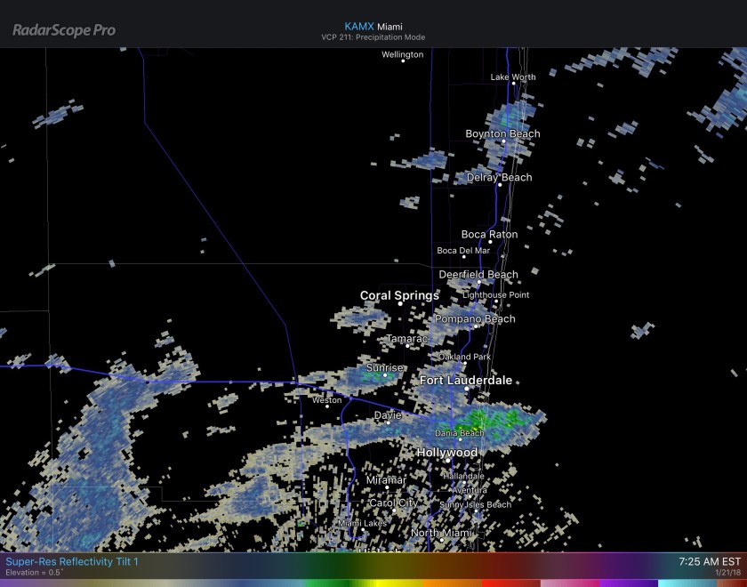
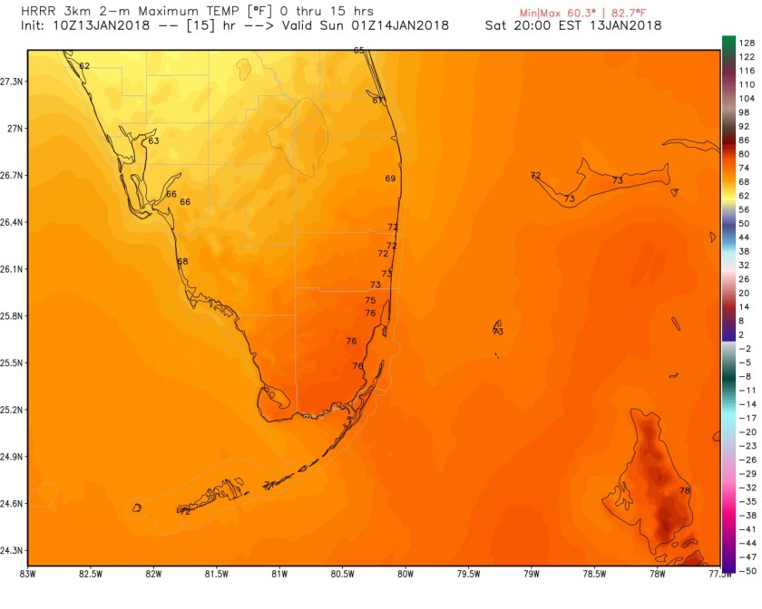
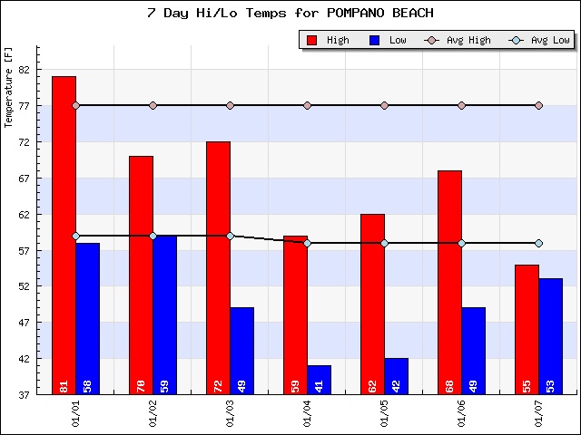
71F with an easterly wind at 21mph with gusts to 31mph this morning in Pompano. There are some quick moving showers that have affected the east coast this morning so watch for slick roads.

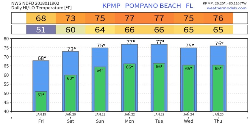
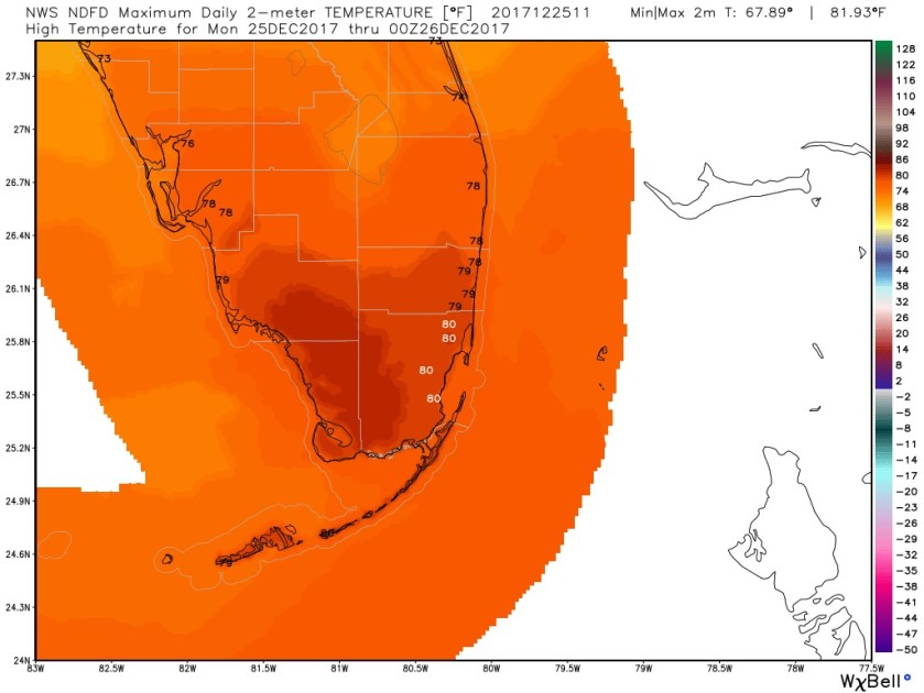
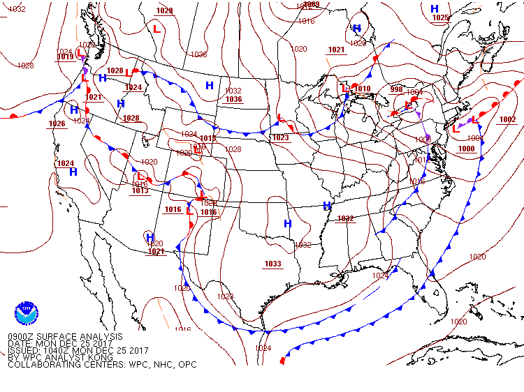
Strong high pressure to our north is providing the set up for our windy conditions. There is a high risk of rip currents at the beaches today with strong easterly wind. A few quick showers will be seen today with a high of 76F with some sun. This is all ahead of a cold front that is now working though the mid-part of the country. This will bring showers and a good chance of a thunderstorm from late Sunday into Monday. Some of these storms could be strong so I am watching for any severe threat.

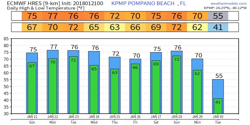
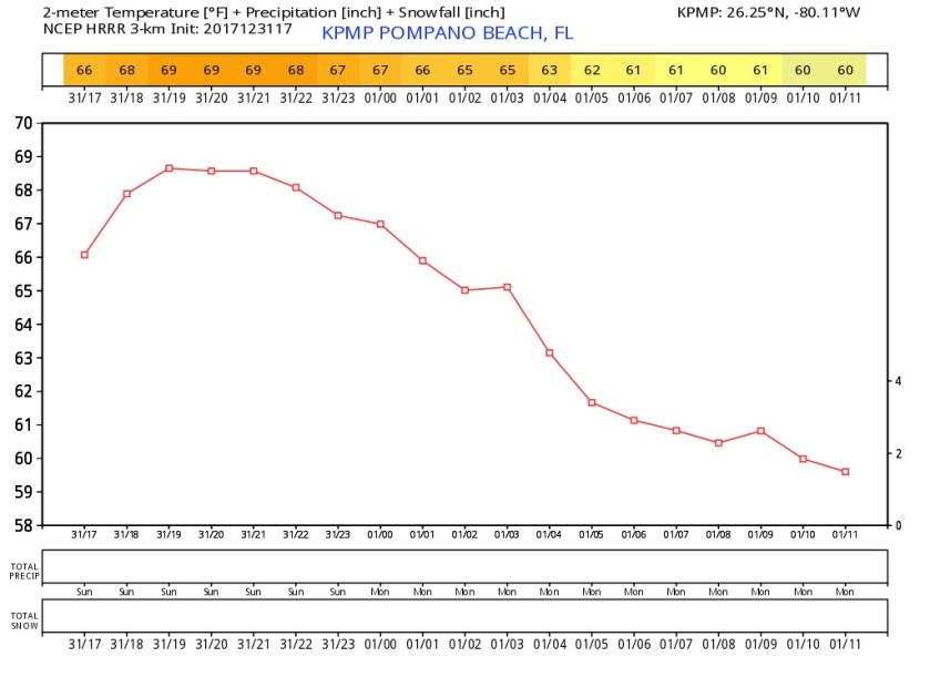
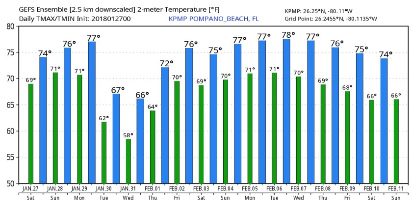
After the front passes through on Monday cooler, drier air will take over through mid-week before we warm up quickly. Here is the latest GEFS showing our temps moderating as we go through next week.

Enjoy your day!

1/21 – Chance of a Passing Shower, Breezy

Good Sunday morning, Pompano is at 73F with a brisk SW wind of 17mph. The clouds from yesterday remain with a better chance of a shower overall today. Showers will be quick and light. Current radar shows the heaviest over SE Broward at the moment.

High today will be 77F and as discussed yesterday we will not see a wide variety of temps this week. This trend continues according to the latest Euro. In the latest run we see a possible front early next week.

Again the only weather hazard is rip currents at the beaches due to the brisk winds. From this morning you can see this from Pompano Beach.

Enjoy our weather today!

1/20 – Nice Weekend Ahead, Warmer with Some Clouds

Not a bad weekend in front of us. Starting the morning at 67F and heading to a high of 75F with clouds. The only weather hazard is a moderate risk of rip currents at the beaches.

Looking at the week ahead we will see an increase in showers around Tuesday ahead of the next front which will not be as sharp as the most recent ones and just moderates our temps. The latest Euro keeps us in a narrow temperature range with lows in the 60s and highs in the 70s.

Enjoy your day!

1/18 – Weekend Outlook, Warmer Friday and Even Warmer Sat/Sun

After a very cool morning, with a low of 42F in Pompano we reached a high of 63F. This was a few degrees warmer than expected.which was welcomed by most. Tonight we will see a low of 52F with out temperatures moderating tomorrow. The NWS forecast shows us getting close to 70F. The hourly breakdown looks like this.

As we go into tomorrow evening we could see some very light coastal showers but nothing too heavy at all. That will be about all for our rain chances through later Sunday. Saturday our temp will be back above 70F. The current NWS forecast for highs and lows:

Enjoy your Friday!

1/14 – Cooler and Clear Today, High 68F

Good morning as we start off at 52F with clear skies. We will warm up to 68F this afternoon with just a few passing clouds today. We will be cool most of this week with an increase in rain chances mid-week ahead of our next cold front. As mentioned yesterday about how cold it could be on Thursday the models have come to much better agreement and we will be in the lower 50s (not the 30s) as it stands right now which is a much more reasonable output. Here are the highs and lows with the latest Euro.

Have a great day!

1/13 – Some Clouds, Mostly Nice and Cooler

The rain has passed for the weekend and we are in store for a mostly nice and cooler weekend. We are currently at 66F in Pompano heading for a high of 73F. Some clouds today but the sun will be around. Here are today’s highs according to the latest HRRR.

As a cold front clears the area out temps will be lower than what we have seen over the last few days. We will see and increase in moisture starting Monday with rain chances boosting up some but no heavy precipitation is expected. Latest NWS highs and lows for the week ahead look like this.

On temp of. One is Thursday morning. Currently there is a 20 degree spread between the GFS (56F) and the Euro (36F) for Pompano’s low. The Euro has been advertising this low for the past day and a half. I will be watching the runs and see where we may be going. I will have quick updates on Twitter ( @PompanoWx ) about this as the weekend goes on. Here is the latest output from the Euro.

Enjoy your day!

1/7/18 – Warmth is Returning with Moisture

After a cold start to our new year our temps have been warming up over the past few days. That will continue today and we may actually get to a high of 70F this afternoon. Currently we are 53F with partly cloudy skies.

Along with this warming trend we could see some showers around, so we may not be as dry as we have been. The latest HRRR gives a hint of this but keeps us shy of 70F.

I am expecting to see some rain as we get to Tuesday/Wednesday of this week ahead of our next shot of cooler air which will not be as sharp as this past week.

Looking back at the past week it has almost been fun to see how our highs have been near our normal lows for this time of the year.

Will update later with this temps we can look forward to this week.

Cool and Rain-Free for NYE2017

Hope you are enjoying our cooler weather on this last day of 2017. For those venturing out tonight we will have rain-free conditions but bring a jacket as we will be approaching 60F around midnight to welcome 2018. For the balance of this afternoon do not think we will get above 70F, as of 2pm we are sitting at 69F in Pompano.

For January 1 we will continue with mostly dry conditions but as we go into the afternoon clouds will increase along with our chance of showers. Clouds will be prevalent Tuesday and Wednesday ahead of our next front that will again dry us out and bring our temps lower. The GFS appears to have a pretty good handle on this and we should see our lows in the upper 40Fs for later this week.

For next weekend we will be cool and dry from what I see at this time but we will update that later this week,

Thank you all for visiting in 2017, I certainly appreciate all your support and kind words and that goes double for when I am wrong.

Have a happy and safe New Year’s Eve!

12/25 – Warm Christmas Day, Sleigh Chance of a Shower

Merry Christmas to all of you, wishing you a wonderful day with family and friends. We will not have any snow but we do have a beautiful day ahead with some morning fog currently and a temp of 63F. If you need a light jacket this morning you will not need it by late morning as we approach our high of 79F. The latest NWS highs for our area look like this.

A stray shower is possible today but it will not heavily impact any new outside toys to be played with. If going out the beaches please watch the choppy surf and check with lifeguards before heading into the water.

The front over central Florida will move south and be off our coast later today. It will not completely clear the area so a chance of rain will continue into tomorrow.

Thanks to the NWS in Miami for sharing the spotter reports this morning in their early morning discussion.

Enjoy your day!

12/16 – Warming Up and Dry

We are about 20 degrees cooler than we were at this time last week at 58F. This will be our last sub-60F degree morning in a row. Our warming trend from yesterday will continue was we climb to 78F with mostly clear skies. Great day to be outside.

High pressure is building into the area and for the next week our temps will be moderate with lows in the 60s and highs in the 70s, maybe an 80F. Cannot rule out a shower, but we will be mainly dry. The latest Euro does not even indicate rain until the second half of the week.

Enjoy the day!