10/14 – Some Rain on this Saturday

82F at 6am in Pompano with scattered showers moving east to west over the area.  At the time of this writing we have shower about to come ashore and affect north Pompano and Deerfield.


Clouds and scattered showers today with the focus being along the coast early this morning and tonight with daytime showers affecting the inland areas.  Clouds will keep our high at 87F this afternoon.  I do not see the rain being as extensive in coverage compared to the last couple days.

Cooler weather outlook,  nothing significant yet.  The latest GEFS shows a very modest decrease in temps over the next couple weeks.  Clouds and rain over the past weeks has given us some relief of the 90s.


Go out and enjoy the day!

10/7 – Nice Saturday Ahead

Starting off today at 82F this morning with some clouds around.  Today we will see the possibility of a shower or two this afternoon, breezy, with a high of 89F.  Beach conditions remain rough with a high risk of rip currents so we are still not safe to be in the water.

When will it get cool and more fall like?  We are not there yet. Looking at the latest GEFS we could see our highs lower over he next two weeks but not seeing any drastic cool down…yet.


Hurricane Nate is not a direct threat to us and will be moving towards the north in the Gulf of Mexico.


Get out enjoy a south Florida autumn day!

9/30 – Morning Somewhat Clear, Afternoon Rain

A humid 73F to start our morning in Pompano with mostly clear skies.  Like yesterday, we will see showers and a possible thunderstorm this afternoon and evening. Some rainfall amounts could be heavy but for the most part most areas should see less than three-quarters of an inch if rain.

Tomorrow could see less coverage in rain but not completely dry.  NWS rainfall forecast for south Florida through Monday morning looks like this:


Tropics, Lee and Maria are far away and losing tropical characteristics. We are watching the area of disturbed weather over us now and another near Puerto Rico.  Not expecting any rapid development at this time but keep up to date as we move into our busy tropical time of the year, October.


Get out and enjoy the day!

9/24 – Showers in the Morning, More Possible this Afternoon

An area of showers with some lightning is overbour area this morning and will linger through mid/late morning.  This will open to to some clearer skies but a chance of more rain is in store for us this afternoon and evening.


Rainfall amounts will not be heavy but enough to keep roads wet so use extra caution when driving and when you hear thunder take shelter. Latest rainfall amounts for the area look like this from the NWS:


High today will 89F as we continue with a risk of rip currents due to Hurricane Maria off our coast moving away.


For the week ahead we will see rain chances drop tomorrow and stay low through Thursday.  Friday and Saturday will see an increase is moisture over south Florida.  Highs remain around 90F with lows in the upper 70s throughout.

Enjoy the day!

9/23 – Showers with Some Sun, Breezy

First off no direct tropical threats in store for us this weekend.  Hurricane Maria is well off our east coast generating rough surf and rip currents for our beaches so do not head into the water this weekend.


Today will be breezy with showers, especially this afternoon, with some possible lightning.  Latest models forecast rainfall amounts between .2 and one inch total today.  Yesterday I had ,56 inches at home.  Here is the latest HRRR for rainfall totals today.


High today will be 90F.  Tomorrow will be about the same with less shower activity from what I am seeing at this time.  Looking into next week our highs and lows will,not change much with the latest GEFS run.


Enjoy your day!

9/16 – Mostly Dry and Very Warm Saturday

Helping all of you have power and got through Irma without many issues.  Having just getting power back I know how uncomfortable and hot it gets.  We will not see any relief from our typical September warmth with partly cloudy skies and a high of 89F.  Just a very outside chance of a shower today as we have the dry air surrounding Jose over us.  Looking ahead we can see the fall pattern setting in with the latest GEFS tenpurture output as we slowly move away from the 90s as highs.

The only weather threat we have is a high risk of rip currents at the beaches due to Jose.


Tropics remain active with Jose well to our east moving north and TD 14 which is not expected to be a system in a few days as it moves off to the WNW.  There is a chance the TD 14 could become Lee later today before weakening.  There is one additional area being watched, in between Jose and TD 14, which is likely to be a depression by the end of the weekend.  Current modeling bring this system up to the Bahamas before turning north, BUT, we need to keep an eye on systems like this.


Stay positive if you do not have power and enjoy your day!

9/11 – Irma’s Highest Gusts and Power Outage

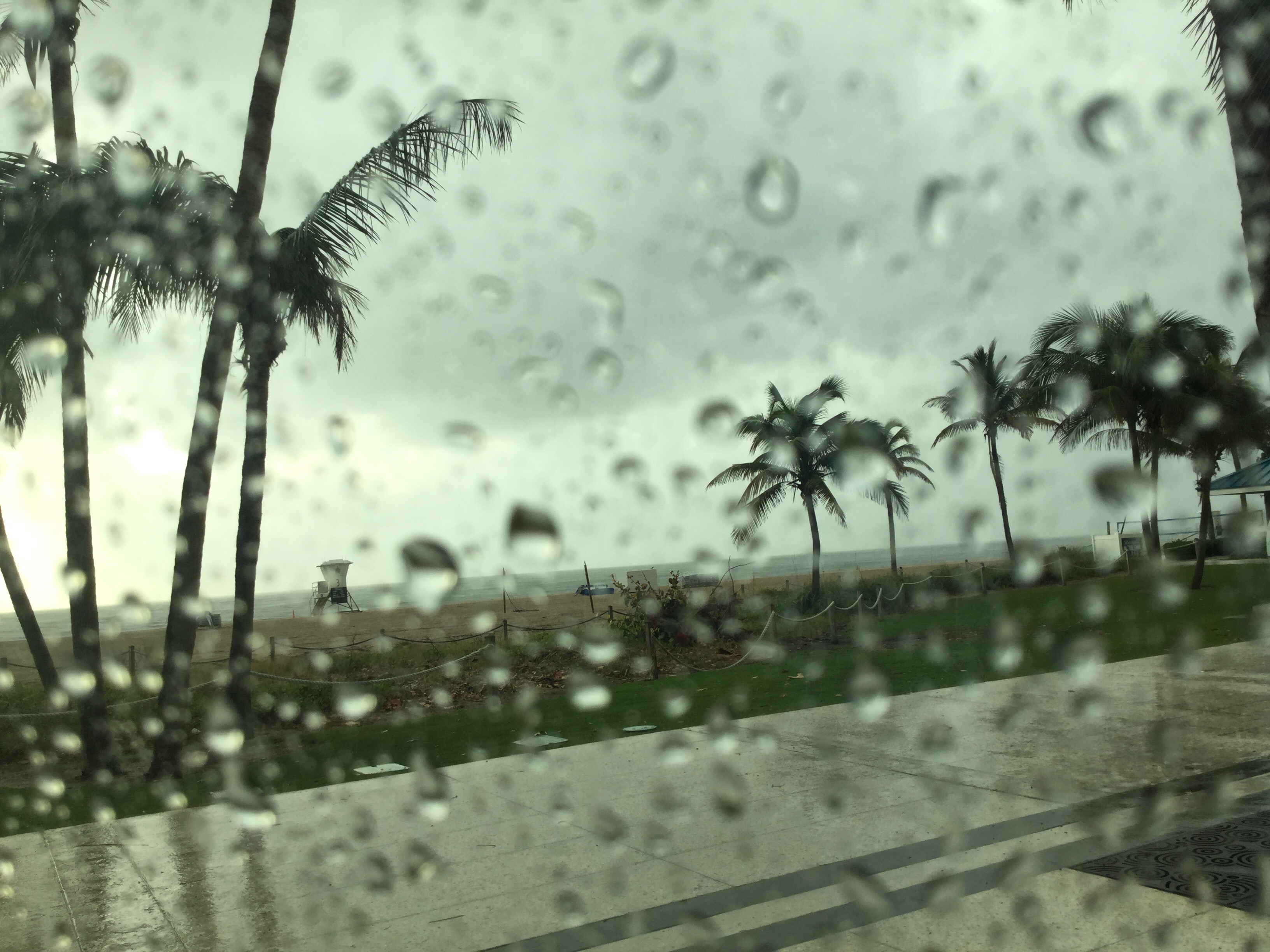
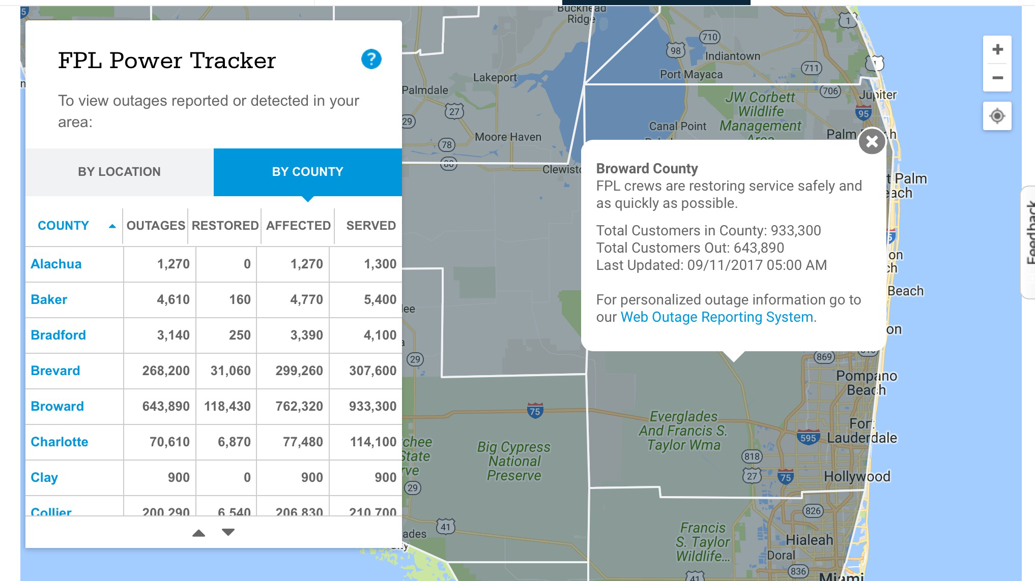
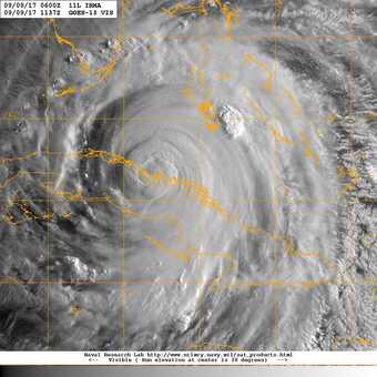
Hope all of my readers in Florida are doing well.  I lost power early Sunday morning and still do not power.  In Broward there is about an 85% outage in the county for power according to their website.


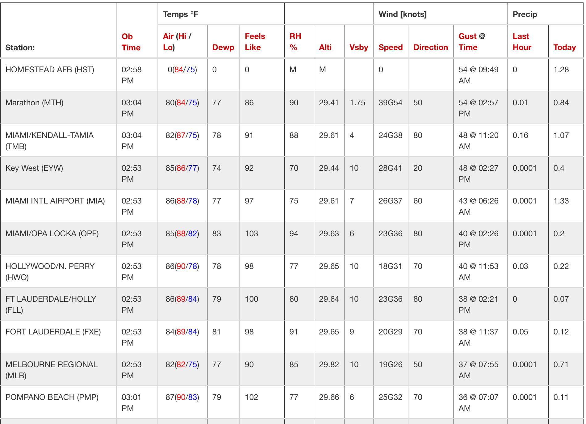
Here are the highest gusts in the NWS Miami service area from Irma.  87mph for Pompano:

Preliminary Wind Gust Reports From Hurricane Irma…
Location Speed

2 ENE Naples 142 MPH

1 E Marco Island 130 MPH

1 S Marco Island 129 MPH

2 SSW Quail Creek Estates 112 MPH

Fiddlers Creek 99 MPH

1 W Ochopee 96 MPH

8 SSE Key Biscayne 93 MPH

6 SSE Princeton 93 MPH

Ilnternational Airport 91 MPH

4 SSE Miami Beach 91 MPH

4 W Royal Palm Ranger 91 MPH

2 ESE Lake Worth 90 MPH

7 WNW Inlikita 90 MPH

6 SSW North Blocks Golde 89 MPH

2 ENE Lake Worth 89 MPH

Pompano Beach Airpark Airpor 87 MPH

2 SW Key Biscayne 87 MPH

2 NE Dania Beach 85 MPH

Juno Beach 84 MPH

2 E Liberty City 84 MPH

2 ESE Miramar 84 MPH

Naples 83 MPH

3 WNW Key Biscayne 82 MPH

1 NE Perrine 82 MPH

Dania Beach 81 MPH

3 SSW Miami Beach 79 MPH

1 E Dania Beach 79 MPH

1 NE Boca Raton 79 MPH

1 NNW Ocean Ridge 78 MPH

1 NNW Doral 77 MPH

2 SE Jupiter 77 MPH

Oasis Ranger Station 77 MPH

Opa Locka Airport 77 MPH

15 W Boca Raton Equestrian 76 MPH

1 S Ortona 75 MPH

1 SSE Riviera Beach 75 MPH

1 NW Miles City 75 MPH

Fort Lauderdale Executive Ai 74 MPH

11 SE Brighton Seminole 74 MPH

3 SW Brighton 73 MPH

5 E Okee Tantie Recreation A 73 MPH

10 WNW Pahokee 73 MPH

8 W Pahokee 71 MPH

2 N Key Biscayne 71 MPH

8 N Dade-collier Train 71 MPH

1 ENE Lely 71 MPH

1 NW Sunrise 70 MPH

2 ESE Fort Lauderdale 70 MPH
I will post more when I am able.  Be safe during your cleanup!

9/9 – Hurricane Irma, Afternoon Update

Irma is winding up again and we should see some strengthening as we go into the evening.  Barometric pressure has dropped two millibars in the past couple hours according to recon.

So far the highest wind gusts in Pompano has been 36mph earlier this morning.  We will see much higher as we head into tonight.  Our peak winds will occur tomorrow afternoon, roughly between noon and 6pm.  As of now we should see sustained winds between 50-65mph and gusts to just above hurricane force.  Continue checking back for further updates.

Latest wind gusts from today across south Florida:


Currently these are the watches and warning for Pompano Beach:

Hurricane Warning / Storm Surge Warning / Tornado Watch / Flood Watch

Next advisory and forecast package will be out at 5pm and will update there after.

9/9 – Hurricane Irma, Morning Update

The 8am intermediate advisory now have Irma’s winds at 130mph due to land interaction with Cuba.  Irma is still moving towards the west at 12mph.  Irma is still a very dangerous category 4 storm, even for the east coast of Florida.  Take this morning as your final chance to get your preparedness plans complete.  

Current satellite image of Irma


Though we may not see the strongest part of the storm, we are going to have strong effects depending on the ultimate path of Irma.

I will be posting throughout the day here and on Twitter.  If you have any questions please reach out to me at @pompanowx on Twitter or the contact box on this site.

Stay safe and be ready.

NWS Forecast, with Windspeeds, as of Friday Morning

This is very subject to change but here is the latest NWS forecast for Pompano:

Coastal Broward-

Including the cities of Pompano Beach, Fort Lauderdale,

Fort Lauderdale Beach, and Hollywood Beach

522 AM EDT Fri Sep 8 2017
…HURRICANE WARNING IN EFFECT…

…STORM SURGE WARNING IN EFFECT UNTIL 10 PM EST MONDAY…
.TODAY…Partly sunny. A slight chance of showers and

thunderstorms this morning…then a chance of showers and

thunderstorms this afternoon. Breezy with highs in the upper 80s.

Northeast winds 15 to 20 mph. Chance of rain 40 percent.

.TONIGHT…Tropical storm conditions possible with hurricane

conditions also possible. Mostly cloudy. A chance of showers and

thunderstorms in the evening…then showers likely with a chance

of thunderstorms after midnight. Lows in the lower 80s. Northeast

winds 25 to 30 mph. Chance of rain 70 percent.

.SATURDAY…Tropical storm conditions expected with hurricane

conditions possible. Showers and thunderstorms. Highs in the

upper 80s. Northeast winds 25 to 30 mph with gusts up to 45 mph…

increasing to 35 to 40 mph with gusts up to 60 mph in the

afternoon. Chance of rain 90 percent.

.SATURDAY NIGHT…Hurricane conditions expected. Showers with a

slight chance of thunderstorms. Lows in the upper 70s. Northeast

winds 45 to 55 mph with gusts up to 75 mph…becoming east and…

increasing to 50 to 70 mph with gusts up to 90 mph after

midnight. Chance of rain 90 percent.

.SUNDAY…Hurricane conditions possible. Showers and

thunderstorms. Highs in the mid 80s. Southeast winds 65 to 80 mph

with gusts up to 100 mph…becoming south 55 to 75 mph with gusts

up to 90 mph in the afternoon. Chance of rain 80 percent.
And putting this is graphic format: