7/16 – Scattered to Numerours Showers, Possible Thunderstorm

At 7am Pompano is at 82F with some passing shower activity in the area.  Latest radar shows more activity offshore moving towards the coast.


Shower activity is expected to increase as we go through the day.  Rainfall amounts will typically be between .10 and .50 inches with higher amounts possible.  Not an all day rain with some sun or high willbe 89F.

Into next week no significant changes or highlights in our weather with a chance of showers most everyday and highs around 90F.


Above is a picture from this morning at Pompano Beach, enjoy the day!

7/15 – Saturday, Some Clouds with a Chance of a Shower

83F is where we are starting the day in Pompano with some clouds.  Radar is much less active compared to the last couple days and overall we will see less rain today as we go to a high of 91F.

Weather threats today are the chance of a scattered thunderstorm and a moderate risk of rip currents.

Looking at the past week we continue our trend of normal to near-normal highs and our lows continue to run above average.  So is it warmer than normal?  Yes, if you look at our daily average temperature which would be about 86.5F compared to the normal of about 84F.  Here is the past week’s data.


Enjoy the day!

7/9 – Sunday with Sun, Some Clouds, Slight Chance of Rain

As we start this Sunday off with 81F in Pompano and some showers offshore we will see a day much like yesterday with warm temperatures and a slight chance of a shower.  Latest radar  shows the activity off the coast.


Today we will see a high of 91F.  

Looking ahead I still think we will see an increase in shower activity later this week  but our highs and lows will be mostly unaffected with around 80F in the morning and around 90F in the afternoons.  The latest GFS continues to show this as well.


Enjoy your Sunday, inleave you with this picture from Pompano Beach this morning as the sun is trying to hide behind one of our offshore showers.

7/8 – Sun and Some Clouds, Chance of a Shower

Not departing from the pattern of the past week, we will see a slight chance of a shower but otherwise highs will be near normal, 90F, and lows above average 83F.  If we see a decent shower or thunderstorm our low will like be sub-80F.  Below you will see today’s forecasted highs from the NWS.


I did have a couple people ask this past week if we have been hotter than usual.  Our highs have not been but out lows are above average as mentioned above.  In fact, this past week Pompano has not been under 80F.  This can be seen in the graph below showing our highs around 90F and lows above 80F, just like the forecast.


Later this coming work week we should see a change in the pattern as the remnants of TD4 moves in our general direction increasing moisture and shower activity.  

Enjoy the day and I will have an update tomorrow.

Happy Birthday America – Weather Looks Very Good for Fireworks Across South Fla

A very typical summer heat and humidity is on tap for this Fourth of July, with a high of 90F along with some clouds.  We will run the risk of a shower or thunderstorm but as we have seen over the past number of days they will not be widespread.

For tonight’s fireworks the latest HRRR shows minimal shower activity, so I do not see any delays or postponements at this time.  Here is the simulated radar for 9pm:


I am also watching an area of disturbed weather in the Atlantic which the NHC indicates a high risk of formation over the next five days.  Nothing for us to be worried about at this time but will continue to watch.  Latest model runs look like this:


Enjoy the Fourth and leave the fireworks to the professional and keep all of your neighborhood pets and children in mind.

7/2 – After Some Morning Showers, Warmth and Sun

Showers and a couple thunderstorms have come ashore this Monring along the Broward and Palm Beach coastal areas.  This activity will focus more inland and on the west coast later in the day and this evening.


Today we will see some clouds with a high of 90F.  Weather hazards are the same as yesterday with lightning associated with any thunderstorm and a chance of waterspouts this Monring along the Atlantic coast.

As far as the Fourth of July, I am taking back the rain chances mentioned yesterday and at his time the guidance shows our pattern will be similar to yesterday and today with some morning showers leaving our evenings mostly dry for fireworks.

Here are a few pictures from Pompano Beach this morning after the showers passed inland – enjoy!


Three Funnel Clouds East of Boca Raton, Florida on July 1, 2017

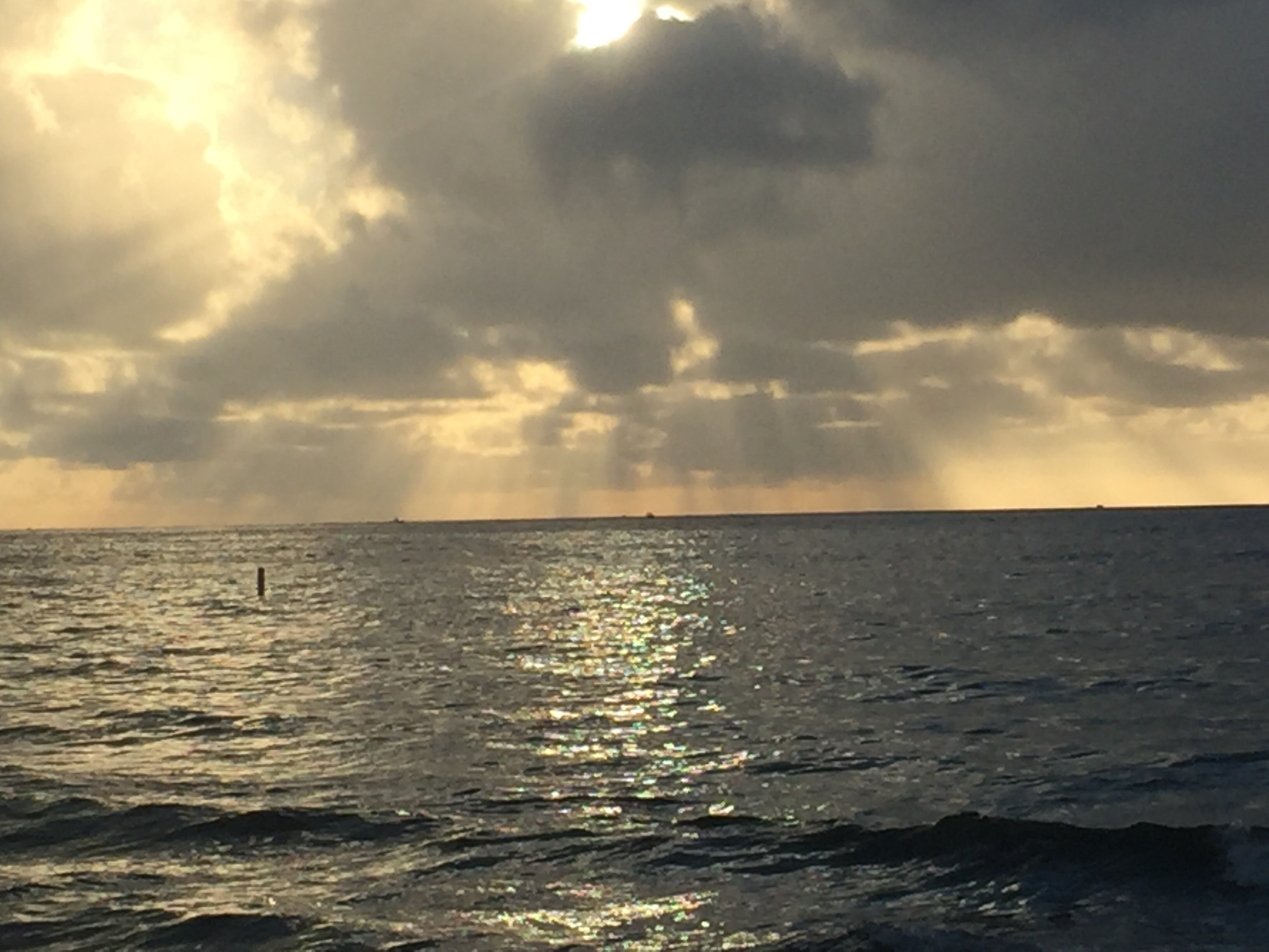
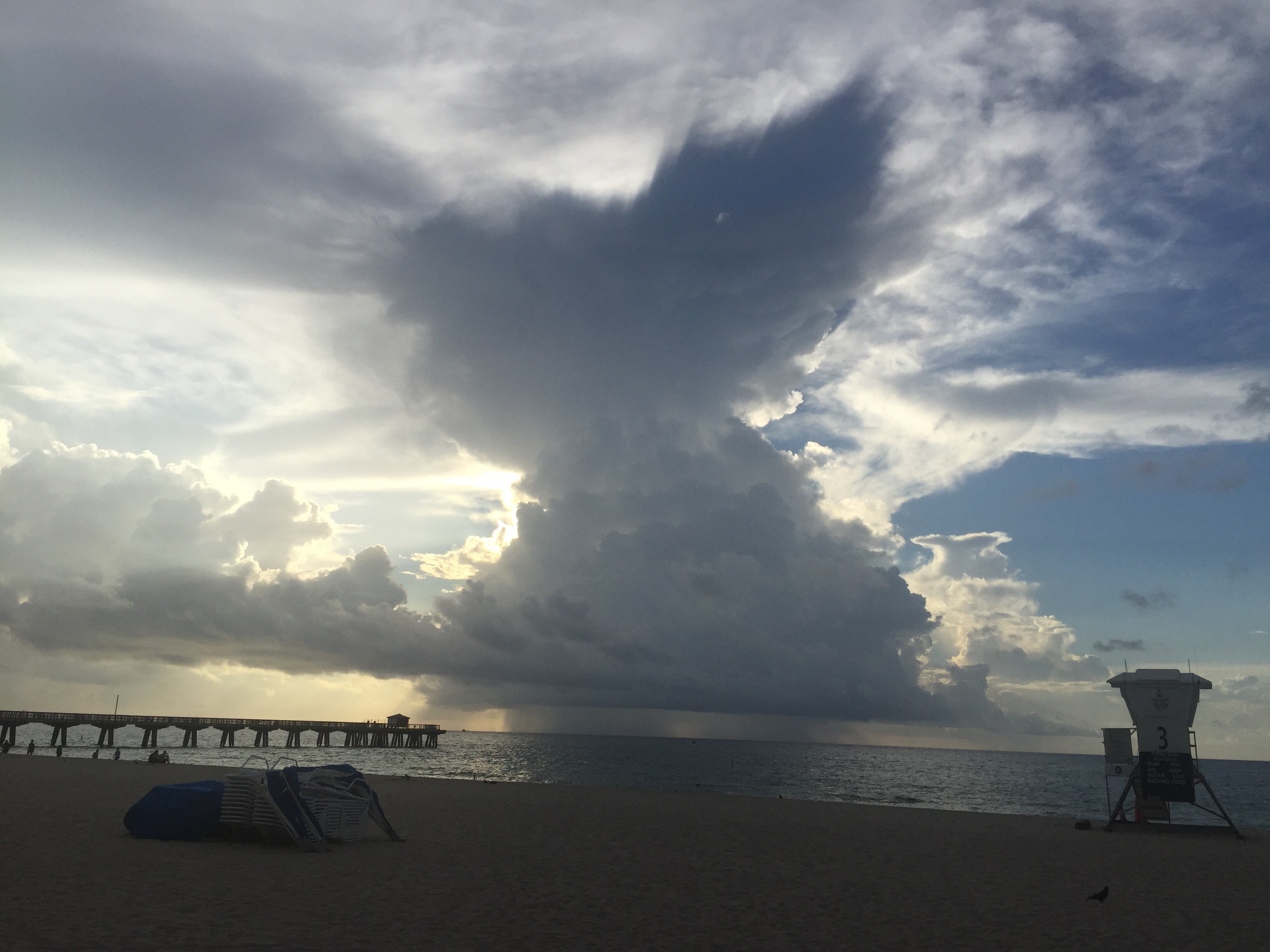
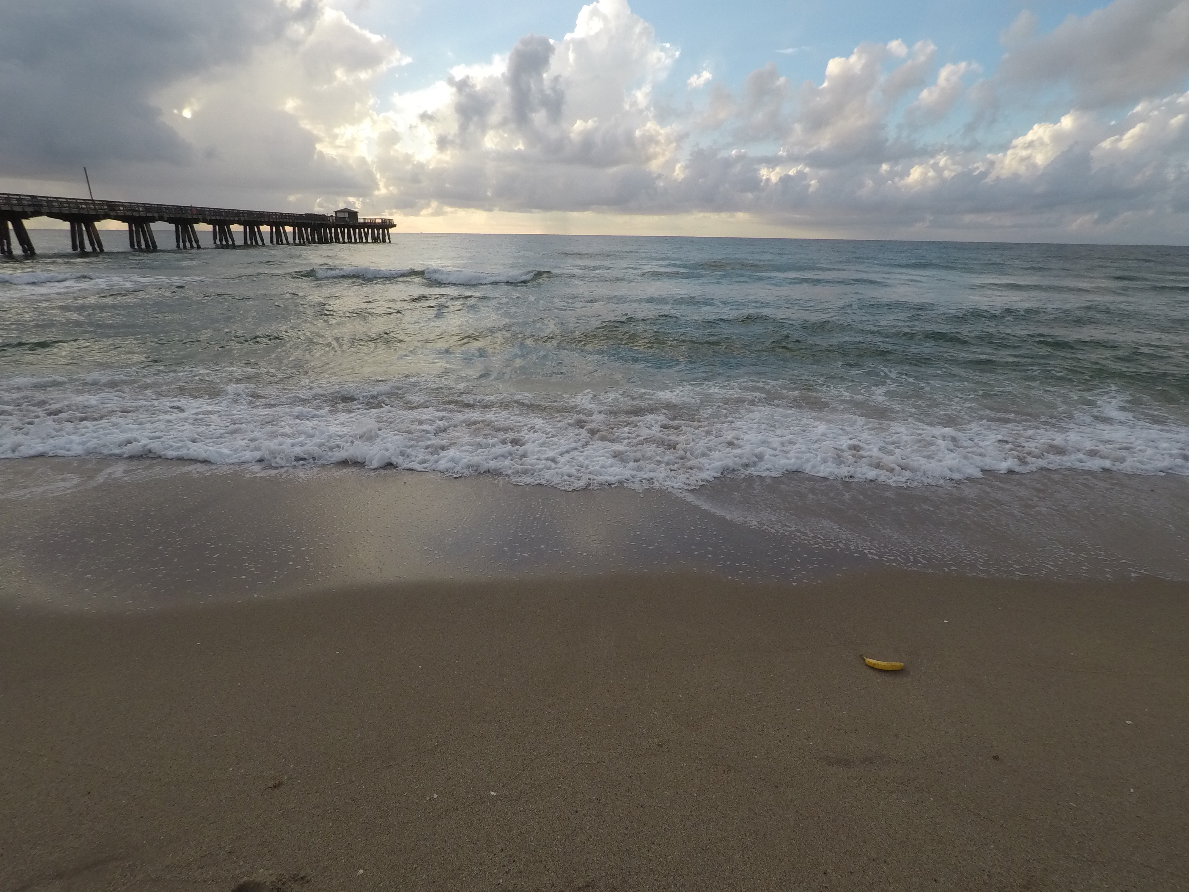
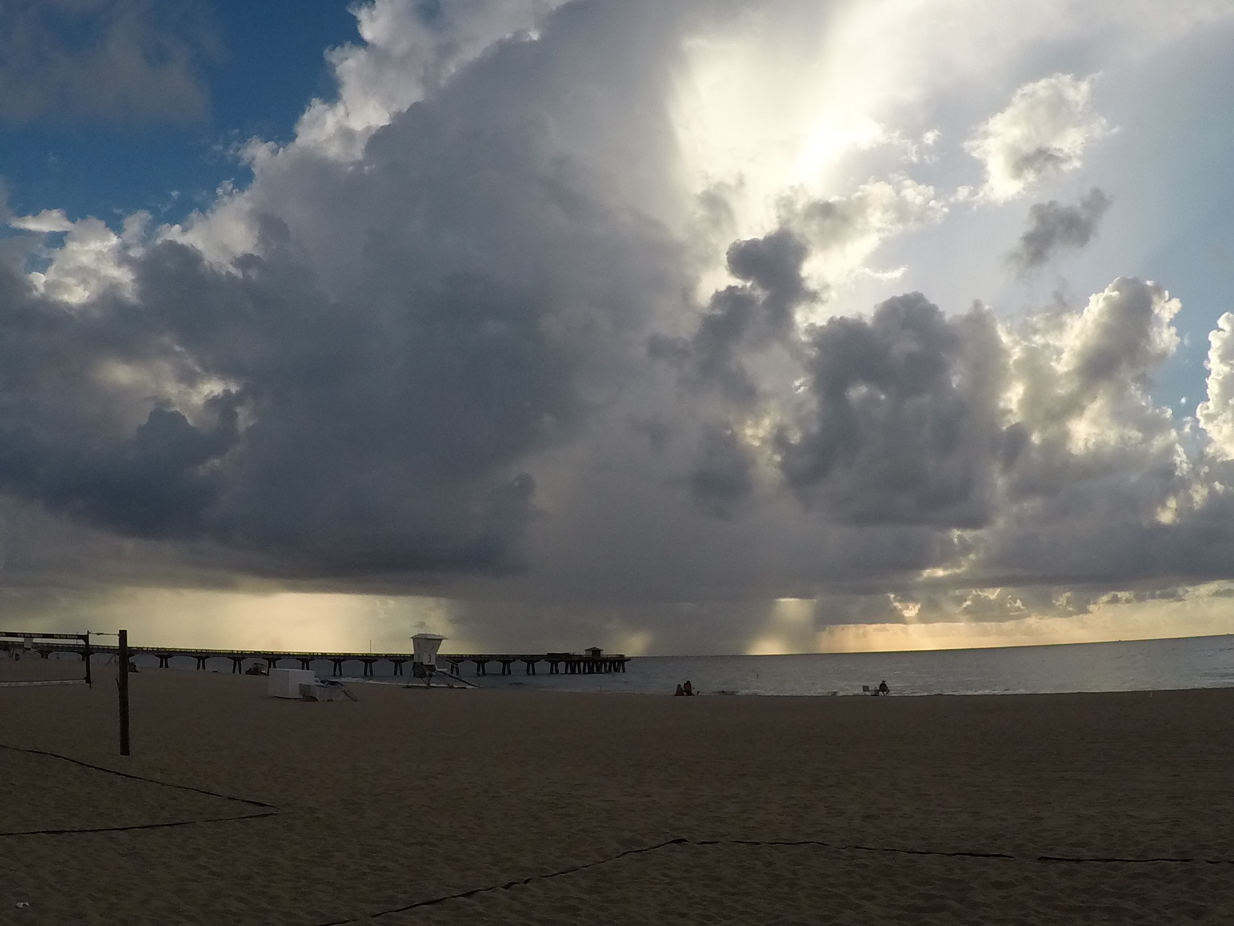
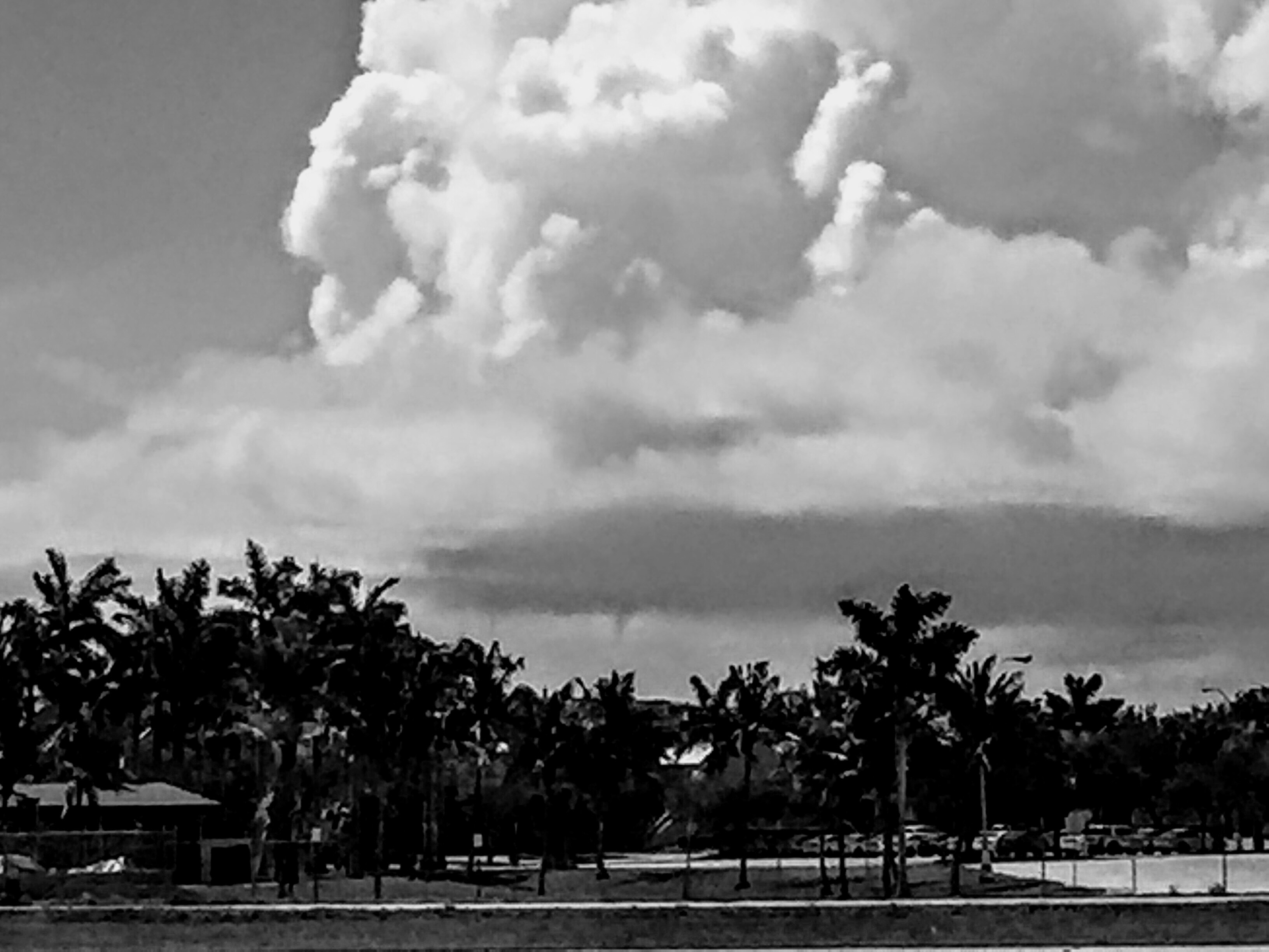
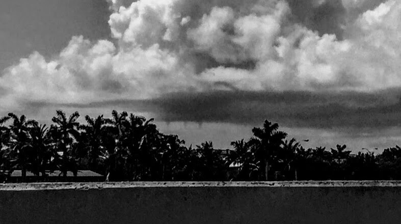
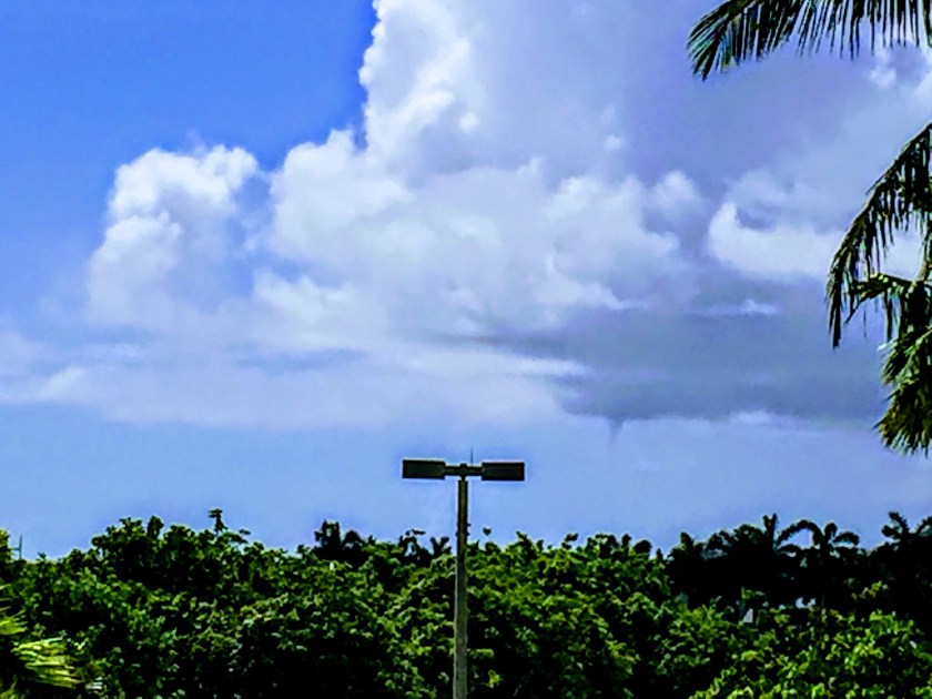
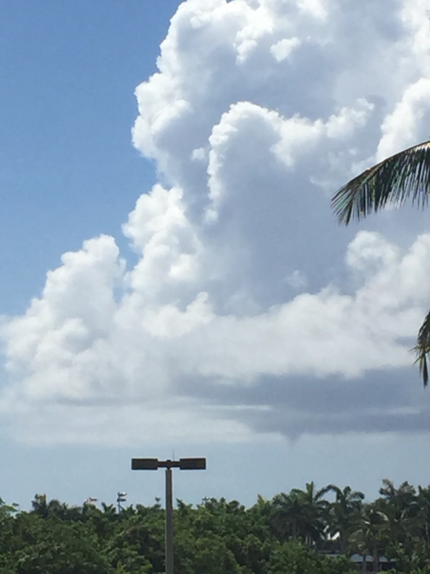
Here are a few images I was able to take of the funnel clouds that were off the Boca Raton coast around 1am on July 1, 2017.  Image have been filtered to help highlight the funnel clouds.


Here is the Specail Marine Warning caused by the funnel clouds / waterspouts:

BULLETIN – IMMEDIATE BROADCAST REQUESTED  

SPECIAL MARINE WARNING  

NATIONAL WEATHER SERVICE MIAMI FL  

1125 AM EDT SAT JUL 1 2017  


THE NATIONAL WEATHER SERVICE IN MIAMI HAS ISSUED A  


* SPECIAL MARINE WARNING FOR…  

  COASTAL WATERS FROM DEERFIELD BEACH TO OCEAN REEF FL OUT 20 NM…  

  COASTAL WATERS FROM JUPITER INLET TO DEERFIELD BEACH FL OUT 20   NM…  


* UNTIL NOON EDT  


* AT 1124 AM EDT…A SHOWER PRODUCING WATERSPOUTS WAS LOCATED OVER  

  HILLSBORO BEACH…OR OVER BOCA RATON…MOVING NORTHWEST AT 5 KNOTS.  


  HAZARD…WATERSPOUTS.   


  SOURCE…RADAR INDICATED.   


  IMPACT…WATERSPOUTS CAN CAPSIZE BOATS…DAMAGE VESSELS AND   

           CREATE SUDDENLY HIGHER WAVES. MAKE SURE ALL ON BOARD ARE   

           IN A SECURE LOCATION AND WEARING LIFE JACKETS.   


* LOCATIONS IMPACTED INCLUDE…  

  HILLSBORO BEACH…BOCA RATON…HIGHLAND BEACH…LIGHTHOUSE POINT…  

  DEERFIELD BEACH AND POMPANO BEACH.  


PRECAUTIONARY/PREPAREDNESS ACTIONS…  


WATERSPOUTS CAN EASILY OVERTURN BOATS AND CREATE LOCALLY HAZARDOUS  

SEAS. SEEK SAFE HARBOR IMMEDIATELY.  

LAT…LON 2632 7996 2623 8003 2630 8011 2642 8008  

TIME…MOT…LOC 1524Z 124DEG 7KT 2631 8005   

WATERSPOUT…OBSERVED  

HAIL…0.00IN  

WIND…<34KTS  

And here is the Special Weather Statement:

SPECIAL WEATHER STATEMENT  

NATIONAL WEATHER SERVICE MIAMI FL  

1102 AM EDT SAT JUL 1 2017  


FLZ168-172-011545-  

COASTAL BROWARD COUNTY FL-COASTAL PALM BEACH COUNTY FL-  

1102 AM EDT SAT JUL 1 2017  


…SIGNIFICANT WEATHER ADVISORY FOR WATERSPOUT MOVING TOWARDS SHORE  

FOR UNTIL 1145 AM EDT…  


* AT 1100 AM EDT…TRAINED WEATHER SPOTTERS REPORTED A WATERSPOUT   

  NEAR THE COAST, WHICH MAY MOVE TOWARDS SHORE BETWEEN POMPANO BEACH   

  AND DELRAY BEACH, IT IS MOVING NORTHWEST AT 5 MPH.  


* LOCATIONS IMPACTED INCLUDE…  

  POMPANO BEACH, BOCA RATON, DEERFIELD BEACH, DELRAY BEACH,  

  LIGHTHOUSE POINT, HIGHLAND BEACH, HILLSBORO BEACH AND TERRA MAR.  


PRECAUTIONARY/PREPAREDNESS ACTIONS…  


A WATERSPOUT MAY MOVE ONSHORE. ALTHOUGH TYPICALLY WEAK AND SHORT   

LIVED, A LAND FALLING WATERSPOUT CAN CAUSE PROPERTY DAMAGE, SERIOUS   

INJURY, OR EVEN DEATH. NEARBY PIERS, MARINAS, DOCKS, AND BEACH   

FACILITIES ARE PARTICULARLY VULNERABLE. HOMES AND BUSINESSES IN THE   

PATH OF THIS WATERSPOUT MAY EXPERIENCE SOME DAMAGE, ESPECIALLY TO   

ROOFS, PORCHES, AWNINGS, AND POOL ENCLOSURES.  


And finally the Local Storm Report:


383   

NWUS52 KMFL 011450  

LSRMFL  


PRELIMINARY LOCAL STORM REPORT  

NATIONAL WEATHER SERVICE MIAMI FL  

1050 AM EDT SAT JUL 01 2017  

1047 AM WATER SPOUT 3 ESE HILLSBORO BEACH 26.27N 80.03W  

07/01/2017 AMZ651 FL TRAINED SPOTTER   


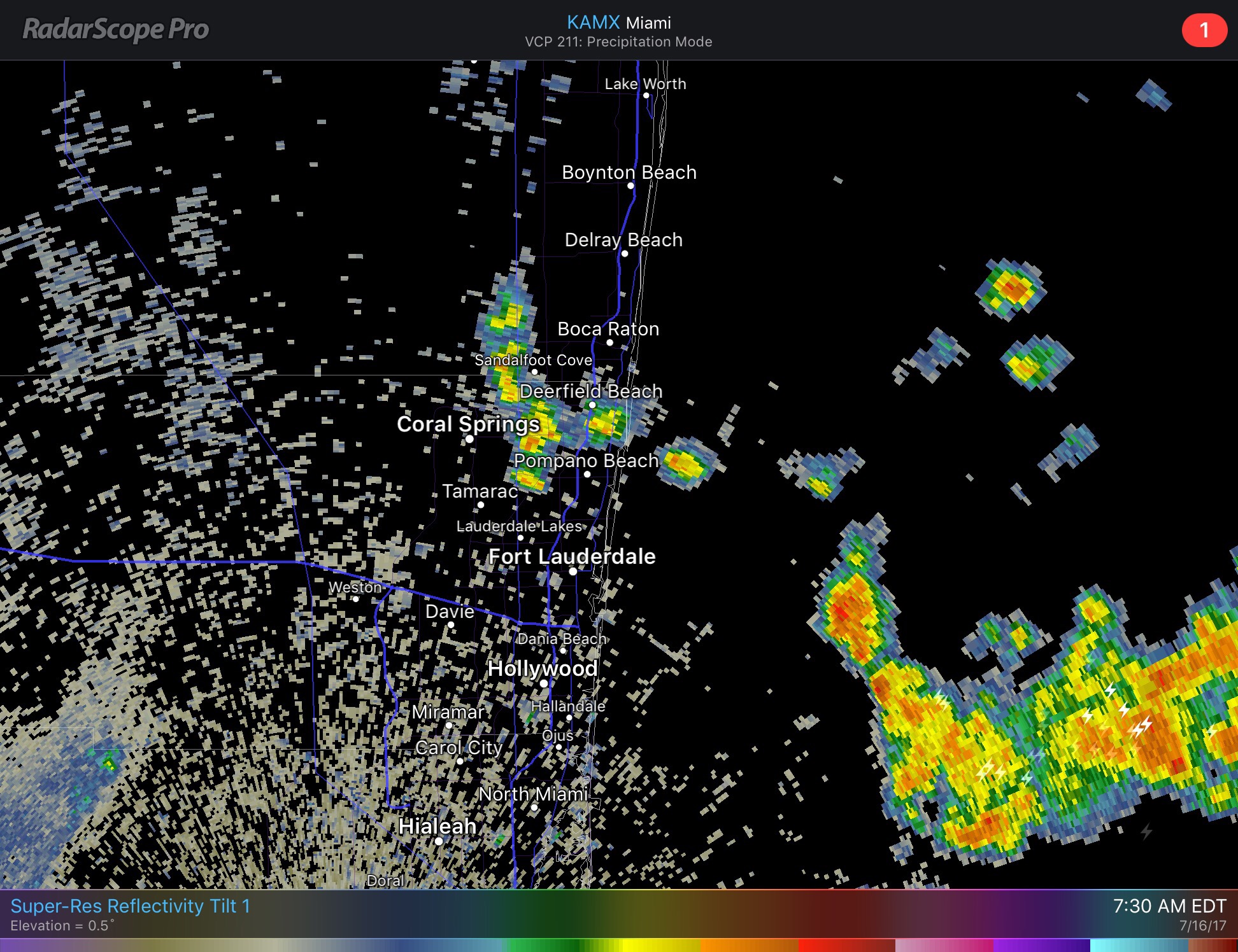
            MULTIPLE WATERSPOUTS BEING REPORTED OFFSHORE POMPANO   

            AND DEERFIELD BEACH.   


  EVENT NUMBER MFL1700253 
First time I have seen three funnels at one time, quite a memeorbale day.  If you have pictures please feel free to share them.

7/1 – Summerlike, Fewer Showers than Usual

As we begin July we are at a very warm 84F at the 5am hour.  Today we will see some clouds and a chance of showers but less than what we would typically see this time of year.  Most of the activity will be in the interior and west coast today.  High will be 90F. NWS Forecasted highs for today:


There is a chance of waterspouts along the Atlantic coast this morning which is our only weather threat at this time.

Looking ahead, tomorrow and Monday we will see a slightly better chance of showers and by Insependence Day we will be about normal for shower and thunderstorm activity.  More details later this weekend for July 4.

Refelecting on June, we were much above normal in rainfall for the months thanks to the beginning of the month rains.  Typically we see about eight inches of rain for the month, June 2017 we received about 15 inches.  This graph shows the daily rainfall along with thenacculmated for the month.  We surpasses the avaerage monthly total by June 6.


And focusing on the past week we can see our highs have been right around average but our lows have been above.


Get out and enjoy the day!

6/25 – Another Nice Day, Possible Shower with Some Clouds

This Monring we are starting at 83F on our way to a high of 89F.  Radar is a bit more active than yesterday with some showers off the coast moving towards the NW which could bring a quick burst of rain.  This will decrease as the day goes on.


Rip currents will still be a concern at the beaches but other than that no other hazards at this time.
Enjoy the day!  Here is Pompano Beach this Sunday morning.

6/24 – Mostly Sunny and Dry, Risk of Rip Currents

Currently 84F in Pompano and we will see a mostly dry weekend, with just a very slight chance of a passing shower through tomorrow.  Our only weather hazard is at the beaches where we have a moderate risk of rip currents.  

Looking ahead our temps will not see much fluctuation, the GEFS shows this over the next 7+ days:


Surface analysis this morning shows we are under the influence of high pressure to our east.  Also seen here are the remnants of Cindy now over Pennsylvania/DelMarVa area.


In comparison to our drier weather this weekend we can see over the past 21 days coastal Broward has accumulated 11-15 inches of rain, much more than “normal” for this time of year.


Have a great day and wear sunscreen if you are out!