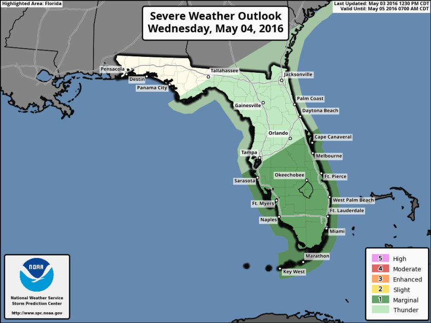
Preliminary Notice Severe Thunderstorm Watch

WWUS30 KWNS 200805
SAW5
SPC AWW 200805
WW 185 SEVERE TSTM AL FL GA CW 200805Z – 201300Z
AXIS..70 STATUTE MILES NORTH AND SOUTH OF LINE..
15S CEW/CRESTVIEW FL/ – 45ESE MAI/MARIANNA FL/
..AVIATION COORDS.. 60NM N/S /18SSE CEW – 6WNW TLH/
HAIL SURFACE AND ALOFT..1 INCH. WIND GUSTS..60 KNOTS.
MAX TOPS TO 550. MEAN STORM MOTION VECTOR 27035.

LAT…LON 31578651 31618448 29598448 29548651

THIS IS AN APPROXIMATION TO THE WATCH AREA. FOR A
COMPLETE DEPICTION OF THE WATCH SEE WOUS64 KWNS
FOR WOU5.

Advertisement

GFS Gets an Upgrade and NWS Gets Mixed Case

After a couple rough days of weather for the mid-west area some “lighter” weather news today.  First, the GFS rolled out an upgrade this morning starting with the 12Z run.  Want to know the changes?  Click here for the details.

ALSO TODAY MOST LOCAL NWS OFFICES STARTED to use mixed case in some of their text products, most notably is the Area Forecast Discussions (AFD).  The first discussion from Miami to use this format was the 7:16am forecast discussion update which looked like this:

issued 716 AM EDT WED MAY 11 2016/

AVIATION...Winds have recently decoupled at most sites,
leading to light and variable conditions across the region.
Prevailing easterly flow will be little lighter today, but still
will see east coast sites increasing to 10-15kts behind sea breeze
around 14Z-15Z. Gulf coast breeze develops and pushes inland of
KAPF after 17Z-18Z with winds becoming W-NW. A few light showers
possible on sea breezes, with a few more showers over interior
22Z-01Z with sea breeze collision. Coverage not high enough to
mention VCSH at this time with no TSRA expected. Winds become
light and variable overnight at all sites.

Note: As of 5AM this morning, NWS Area Forecast Discussions will
now be in mixed case.

/ALM

More text products will be added as the year goes on.  Still weird to see lower-case in these messages after years of ALL CAPS and minimal punctuation.

KPMP_2016051118_min_max_16

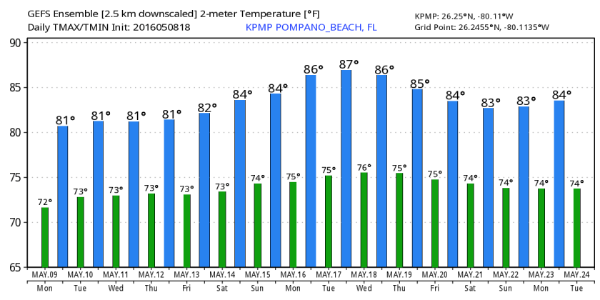
As for the weather itself, we remain warm with slightly above normal highs and lows through the next several days with a chance of showers starting tomorrow.

Skywriting Caught with Bloom Sky Camera

Pompano Bloom Sky 150508
Click the link above to see skywriting streaming off towards the west this afternoon.  We had a great May afternoon with lower than usual humidity on this Mother’s Day.  After starting with a low of 61F this morning we reached a high of 81F.

For the week ahead we will see a slight warm up with only a slight chance of rain as we get into the later half of the week, highs in the lower 80s and lows just above 70F.