12/23/2018 – Liked Yesterday? You Will Love Today

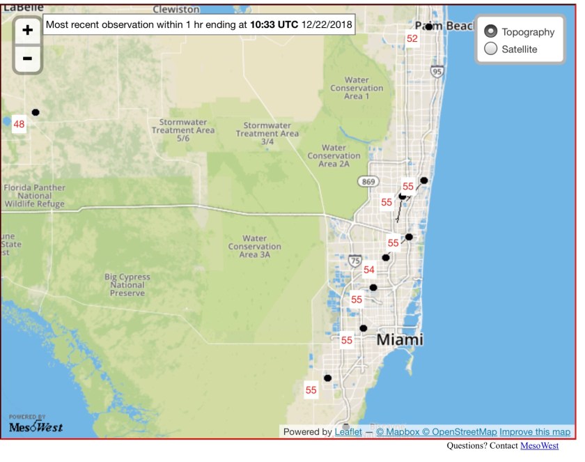
We are coming off our lows from the morning, currently 57° in Pompano as well as the rest of the airports in the area.

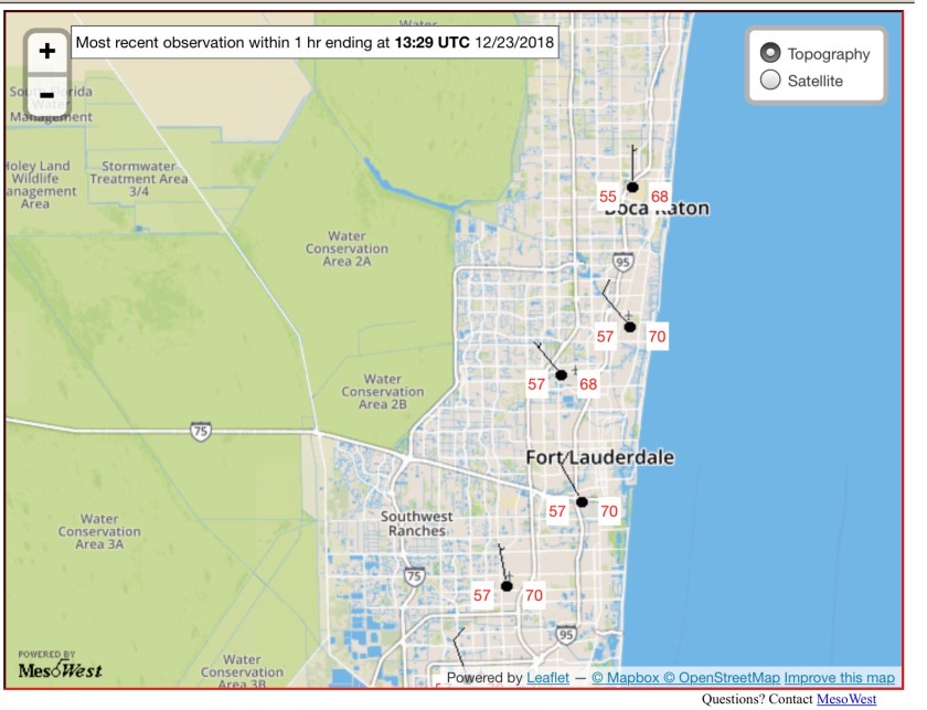
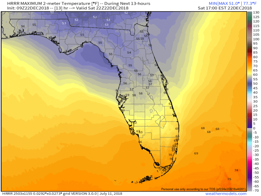
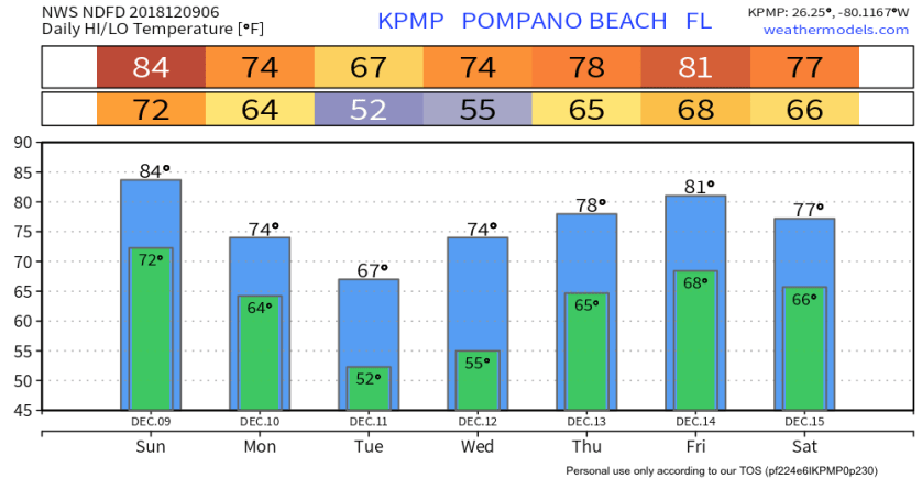
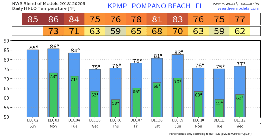
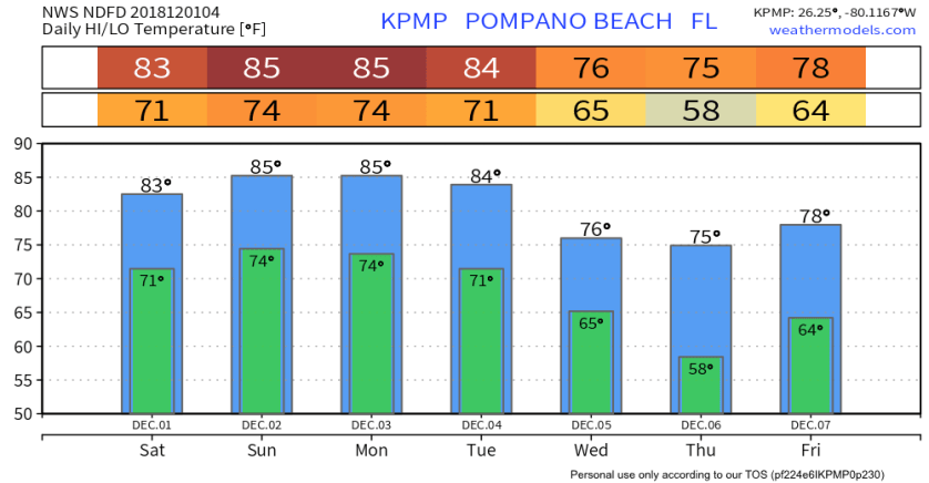
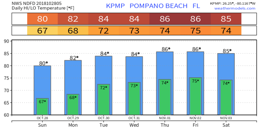
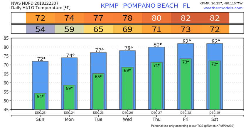
Yesterday we did get up to 70° and expecting to get a few degrees above that today with mostly clear skies and no rain. As mentioned yesterday we will se a gradual increase in temps over the next several days with minimal chance of rain through Wednesday. Thursday we may have a front approach the area that will bring rain back into the area. Forecasted temps over the next weeks look like this.

Christmas Eve and Christmas Day look like perfect south Florida weather with highs both days in the 70s and just a touch coolness in the evening.

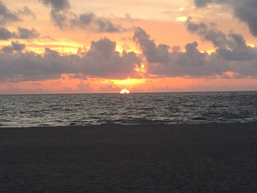
With weather like this please get out and enjoy it.

12/22/2018 – Cooler and Less Wind

After a a storm Thursday and a windy Friday our weather will be calming down today through Christmas. Currently 55° across most of the reporting sites, so have a jacket ready this morning.

Today’ s headline is the cooler weather where we will struggle to get into the upper 60s, high today will be 67°F. Latest HRRR shows a rather cool Saturday across all of Florida.

No rain today as we have much drier air over us now and will not see any measurable rain through Christmas.

This will be our coolest day for the next week as we gradually warm up over the next five to seven days.

Enjoy your day!

12/9/2018 – Cold Front Today, Possible Strong Storms

The cold front mentioned yesterday will progress across the state today brining a chance of severe storms this afternoon to the area. Weather hazards today are:

HIGH RISK OF RIP CURRENTS ATLANTIC BEACHES…
…ISOLATED STRONG TO SEVERE STORMS POSSIBLE TODAY…
…ISOLATED WEAK TORNADOES POSSIBLE TODAY…

Current severe threat categories for Florida

Current satellites image shows the front clearly over northern Florida

Looking at the latest HRRR you can see the cold front move through as we progress through the day.

Showers are possible anytime today but the focus and the more likely time for any of the strong to severe storms will be between 4pm and 7pm in the SE Florida area.

Rainfall amounts are not likely to be high with most areas not exceeding .15 inches around Pompano.

Will be cooler tonight but our coldest morning will be Tuesday and Wednesday so have the jacket ready. NWS highs and lows for the next week:

Storm Reports from December 8, 2018 – Funnel Clouds East of Boca and Lighthouse Point

There was several reports of funnel clouds and a waterspout from today, December 8, 2018. I was lucky enough to get a couple pictures of the funnel cloud east of Boca Raton at 1033am. NWS Miami issue a Special Marine Warning and a Special Weather Statement for the funnel cloud / waterspout from about 115pm.

Here are the Local Storm Reports for today’s activity:

0115 PM     WATER SPOUT      2 SSE LIGHTHOUSE POINT  26.26N  80.08W
12/08/2018                   AMZ651             FL   STORM CHASER

            LIFEGUARD AND TRAINED SPOTTER REPORTED NEARSHORE
            WATERSPOUT LASTED BRIEFLY AT HILLSBORO LIGHTHOUSE.

0120 PM     WATER SPOUT      2 ENE LIGHTHOUSE POINT  26.29N  80.05W
12/08/2018                   AMZ651             FL   TRAINED SPOTTER

            TRAINED SPOTTER OBSERVED ONGOING WATERSPOUT AT THE TIME
            OF CALL TO THE SOUTHEAST OF HILLSBORO LIGHTHOUSE.

1033 AM     WATER SPOUT      7 E LIGHTHOUSE POINT    26.30N  79.97W
12/08/2018                   AMZ650             FL   TRAINED SPOTTER

            TRAINED SPOTTER SENT PHOTO VIA SOCIAL MEDIA OF A FUNNEL
            CLOUD TO THE EAST OF BOCA RATON, THAT DISSIPATED BEFORE
            THE ASSOCIATED SHOWER REACHED THE SHORE.

12/8/2018 – Next Front Arrives Tomorrow

Our next front will approach and sweep through the area tomorrow afternoon. Sunday will start out fairly nice with partly cloudy skies and the wind will pick up ahead of the front. There is a better chance of severe weather to our north versus our chances in the southeast part of the state with the main threat being gusty winds and a possibility of tornadoes. This will need to be monitored as we go through the day tomorrow.

Timing for us according to the latest HRRR is late afternoon for the front to reach us and quickly move through, this is the latest simulated radar.

Before the rain sets in we will get up to 82F. Monday morning’s low should be 65F. Tuesday morning will be our coolest with a low of 53F.

I will updated tomorrow morning with the latest on our severe threat and expected timing.

Good night.

12/2/2018 – Warm and Not as Breezy, High 86F

It is December but the thermometer does not agree this morning. At 7am we are at 79F with a dewpoint of 73F. When you walk outside you will feel the mugginess. All areas of southeast Florida are in the 70s.

Like yesterday we will have clouds but not as breezy and a touch warmer with a high of 86F. Any rain, like yesterday, will be light and fairly quick moving. Next real chance of rain will be on Wednesday in association with the next cold front that will bring us cooler weather for the second half of the week ahead. Looking at the blend of models output for the next week we can see two drops in temps ahead but we cannot count on that second one…yet.

Enjoy your day!

12/1/2018 – Warmer and Breezy Today

Currently we are about 10 degrees warmer than our high of 65F on Wednesday along with some clouds and breezy conditions in Pompano.

Not expecting any significant rain today with a high of 83F. Any shower today will be quick and light. Tomorrow a slightly better chance of measurable rain and a few degrees warmer with a high of 86F. Temps for the next week look like this.

Next cold front will come through later Tuesday dropping our highs back into the 70s for the balance of the week. At this time no significant weather is expected with the passage of the front but will keep an eye on it. Forecast chart for Wednesday morning shows the front well to our south at the time.

As mentioned rainfall will be very minimal in south Florida with heavier amounts going into the central and northern parts of the state. Forecasted rainfall totals through 8am Monday are:

Yesterday needed the 2018 Hurricane Season. I will post a summary later today of the activity.

Enjoy your day!

11-22-2018 Happy Thanksgiving, Black Friday and Weekend Forecast

With a partly cloudy and warm 82F in Pompano a Happy Thanksgiving to all my readers. Yes, there are some showers around so carefully time your deep-fried turkey sessions outside.

There was a waterspout reported three miles off of Deerfield Beach this morning so mariners should keep a cautious eye out during some of the activity this afternoon.

As we go into the evening not really expecting much change as our weather pattern will not change much today or tomorrow. Low tonight will be 68F and for Friday a high of 81F. If venturing out for Black Friday shopping tonight or tomorrow keep your umbrella near for those showers. Overall mostly pleasant weather for this time of the year.

We do have a combination of a weather features including the front that moved tough the area yesterday decreasing moisture in the atmosphere and an approaching short wave from the Gulf of Mexico that will provide some energy for the shower development we will see into tomorrow. Forecast map for tomorrow 8am depicts this.

For the balance of the holiday weekend we will warm a bit more Saturday and Sunday, highs about 85, along with a few showers. Next cold front should sweep through Tuesday dropping our lows to about normal for this time of the year and giving us a break from the showers. Looking further out not really seeing any significant shifts in temps.

Enjoy your time this holiday and I will get an update out later in the weekend.

11/4/2018 – A Change in Weather From Yesterday

We are waking up this Sunday morning to a bit warmer and damp compared to yesterday. The front that swept through Friday evening moved further south than expected giving us a dryer day than expected yesterday. Then early evening yesterday the front started to retreat back to the north bring rain last night to the area and warming us up a bit overnight. At 7am we are at 80F with most of the shower activity to our north. Latest satellite imagery shows the boundary just to our north.

For today we should see a high of 85F with still a chance of a shower but nothing widespread. Most of the rain. Ow associates this this warm front will be over the central and northern parts of Florida. HRRR depicts this well and here is the general rain areas for this afternoon.

Going into the week. It much change in temps expected until we get to late week when the next front will approach the area and will bump rain chances up.

Election Day forecast should be mostly dry and pleasant giving us no reason not to vote, if you have not done so already.

Here is Pompano Beach this morning at sunrise with a few clouds and a nice easterly breeze. Enjoy your day!

10/28/2018 – Fall Arrived in South Florida

Step outside this morning and you will feel a change in the air. After a high yesterday of 90F we are at 63F as of 7am. Almost all areas of south Florida are in the 60s as we start this Saturday.

Today will be a “Chamber of Commerce” day with a few clouds and a high of 80F. Hourly temps through the next 30 hours will look like this.

So after another night in the 60s we will return to our lows in the 70s for the next week or so. No significant weather is expected this week including what should be a pleasant Halloween evening with barely a chance of rain and moderate temps. Next chance of rain will be on Thursday and going into the weekend. NWS forecasted highs and lows are not bad at all.

Certainly, get out and enjoy our Fall weather today. Here are a couple picture from Pompano Beach from this morning.

Enjoy your day!