NWS Forecast, with Windspeeds, as of Friday Morning

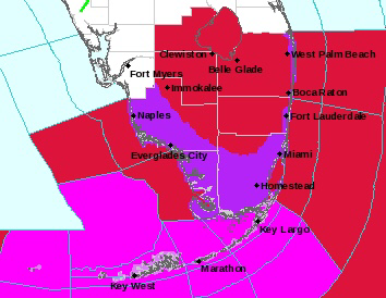
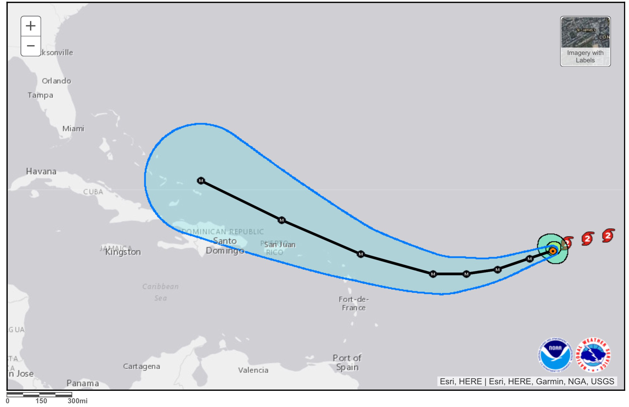
This is very subject to change but here is the latest NWS forecast for Pompano:

Coastal Broward-

Including the cities of Pompano Beach, Fort Lauderdale,

Fort Lauderdale Beach, and Hollywood Beach

522 AM EDT Fri Sep 8 2017
…HURRICANE WARNING IN EFFECT…

…STORM SURGE WARNING IN EFFECT UNTIL 10 PM EST MONDAY…
.TODAY…Partly sunny. A slight chance of showers and

thunderstorms this morning…then a chance of showers and

thunderstorms this afternoon. Breezy with highs in the upper 80s.

Northeast winds 15 to 20 mph. Chance of rain 40 percent.

.TONIGHT…Tropical storm conditions possible with hurricane

conditions also possible. Mostly cloudy. A chance of showers and

thunderstorms in the evening…then showers likely with a chance

of thunderstorms after midnight. Lows in the lower 80s. Northeast

winds 25 to 30 mph. Chance of rain 70 percent.

.SATURDAY…Tropical storm conditions expected with hurricane

conditions possible. Showers and thunderstorms. Highs in the

upper 80s. Northeast winds 25 to 30 mph with gusts up to 45 mph…

increasing to 35 to 40 mph with gusts up to 60 mph in the

afternoon. Chance of rain 90 percent.

.SATURDAY NIGHT…Hurricane conditions expected. Showers with a

slight chance of thunderstorms. Lows in the upper 70s. Northeast

winds 45 to 55 mph with gusts up to 75 mph…becoming east and…

increasing to 50 to 70 mph with gusts up to 90 mph after

midnight. Chance of rain 90 percent.

.SUNDAY…Hurricane conditions possible. Showers and

thunderstorms. Highs in the mid 80s. Southeast winds 65 to 80 mph

with gusts up to 100 mph…becoming south 55 to 75 mph with gusts

up to 90 mph in the afternoon. Chance of rain 80 percent.
And putting this is graphic format:

Watching Irma

Trying to post more frequently as Irma approaches south Florida.  A couple links for the most up to date information on Irma can be found on the National Hurricane Center’s website, which at times has been a bit slow to load today.  Another great site is Weather Undergroud’s tropical section that updates as the NHC issues advisories and statements.

Also please follow this site on Twitter updates as well.

For those in south Florida please take the time to prepare for Irma!  In the meantime enjoy my picture from Target tonight of the lack of bread items.

A Few Notes About Irma – Too Early to Tell

I have received a few calls and emails this afternoon and evening about Irma.  All of us want to know where it will go, and when, and how strong.  The honest answer to all of those questions is that it is still too early to tell.  There are so many factors that we do not know yet that the best answer to just to be ready.  Ready as we all should be at the start of hurricane season.

There is a lot of misinformation I have seen tonight and it clouds the real story for those who may not know what it is like to experience a hurricane or are just confused.  Some examples:

Irma is to be a category 6 – there is no such thing and the NHC, WMO, or any organization will not just come up with a new standard in middle of a season.  

Irma is going to obliterate a city – we do not know where it will go, and no idea of how strong,  Again just a way to get us to click a link.  Do not do it.

Stick to the sources you know and trust.  And when in doubt the National Hurricane Center will give you the official word along with your local National Weather Service office.  For those of us in south Florida that would be the Miami office.

I enjoy sharing my thoughts, my forecasts, and my opinions on our weather but would never want to confuse my readers or contradict official sources.  I will always do my best to respond to your tweets and questions along with providing relevant information.

So for Irma, the best we can do right now is stay informed.  Check in on the storm’s progress a few times a day as we go into this week.  Pick up any supplie you may not have or might be low on.  Especially batteries and water since they are always in short supply as a storm nears.  There is no need to panic, just prepare at this point.

Oh, and here is the latest on Irma from the National Hurricane Center as of 8pm tonight.  Advisories and official track forecasts are issued at 5am/pm and 11am/pm.


Check back tomorrow for more.

9/3 – Mostly Dry, Clouds, and Warmth. Watching Irma

We are starting this Sunday off at 79F in Pompano with some clouds. Today should be much like yesterday with a couple stray showers along the coast, more inland and on the west coast.  High today 91F.  The latest HRRR shows the area’s highs looking like this:


Continuing our summer trend into the first couple days of meteorological Fall is that we are still, running slightly above average for our lows while our highs are just about average.
 

IRMA – too early for anything except to be prepared.  I am confident that there will be a hurricane in the Atlantic moving towards the United States.  Whether there will be a direct impacts or not cannot be determined this far out.  We will all be watching as this storm evolves and by Tuesday there could be some scientific confidence of track and areas that could be more or less in the path.  Until then, be aware that Irma is out there and stay informed through reliable media.  There is plenty of mis-information out there.  Here is the latest forecast for the NHC.


Enjoy the day and I will have an update on Labor Day.

8/26 – Flood Watch Until 8PM, Showers Expected Today

The Flood Watch continues today through today as a tropical disturbance currently located near Tampa begins to move off to the northeast.  Like yesterday, not an all day rain but when showers do setup expect the rain to linger for a while.  So not the best outdoors day.

Highs today will be 89F with mostly cloudy skies and at this moment looking at about the same tomorrow.

Here is this morning’s surface analysis showing Hurricane Harvey in southern Texas and the tropical disturbance near Tampa (L).


Enjoy the day!

8/13 – Typical Summer Day Ahead, TD 8 Forms

I think this is about as normal as a summer day can get for Pompano.  Starting off at 82F with mostly clear skies our temp will climb to 90F as we have some showers and thunderstorms develop this afternoon.  Nothing widespread but they will be around.

This pattern will continue for the next week with no exceptional chances of rain or temperature variation.  As seen in the latest GEFS output temps looks very predicatiable,


TD8 formed yesterday and is expected to strengthen.  This system will pose no direct threat to Florida or at this time the east coast.  The latest NHC forecast keeps the system well off the coast and away from any land areas.


Get out and enjoy some of our south Florida weather today.  Here are a couple of pictures from Pompano Beach this Sunday morning.

Rainy Start to the Work Week

A non-tropical low in the eastern Gulf of Mexico is being watched by the NHC for tropical development.  This feature will bring rain and thunderstorms to most of the start with the concentration over the central and northern parts of Florida.

Current IR satellite of system


8pm Tropical Weather Outlook for system.


Latest rainfall totals for the area through Tuesday evening.


 Areas of localized flooding, gusty winds, and lightning are the weather threats to monitor for over the next day.

7/30 – Showers and Thunderstorms this Afternoon and Evening

A very nice morning to get today started with mostly clear skies and a temp of 82F.  Showers and thunderstorms are expected to develop and become more widespread as we go into our Sunday afternoon and evening with a high of 91F.  Below are the NWS forecast for highs and rainfall amounts in our area.


Going into the work week we will see more showers compared to last week with our highs around 90F and lows remaining around 80F.  The latest GEFS shows this trend continuing.


Tropics are not very active at the moment but as we head into August we will see more waves develop, do not let your guard down and continue picking up supplies.

Here is this morning’s sunrise picture from Pompano Beach:


Enjoy your day!

7/23 – Fewer Showers, High 89F

A breezy 83F to startbour Sunday off in Pompano Beach with the few scattered showers from the pre-dawn hours dissipated.  There is a clusters of thunderstorms affecting the West Palm Beach area but besides that not much else along the coast at this time.


With drier air filtering in we will see fewer showers and most of them will again be inland and slow movers in the afternoon time frame.  Otherwise we will have a light to moderate breeze with a high of 89 with some hazy conditions due to some African dust caught up in the middle layers of the atmosphere.

The week ahead we do not see much change with a slight increase in shower activity after Tuesday.  Temps will be mostly in the low 80s in the morning and around 90F for our highs.  Latest GEFS shows this as well.


Tropics are quiet at the moment with no areas being watched.

Here is a morning picture from Pompano Beach, enjoy your day!