Stop Guessing the Weather: Why You Need Pompano Weather in Your Inbox
Let’s be honest: weather apps are great for a quick glance, but they don’t tell you the whole story. They don’t tell you why it’s going to rain right when you planned a beach day, or when that humidity is finally going to break.
That’s where Pompano Weather comes in.
We’ve revamped our newsletter schedule to give you exactly what you need, when you need it—whether you’re a Pompano local, a Theme Park regular, or just a space geek watching the skies.
[Subscribe to Pompano Weather on Substack]
Why Subscribe?
You get “tell it like it is” forecasting. No sugar-coating, no hype—just the data you need to plan your week, delivered with a bit of personality.
The New Schedule
We are now publishing three times a week to cover every angle of Florida living:
📅 Sunday Nights: The Weekday Outlook
- Focus: Monday through Friday.
- What you get: A detailed breakdown of the work week. We tell you which days to pack the umbrella and which days are perfect for a lunch break outside.
🔭 Tuesday Nights: The Long-Range Look
- Focus: The week after next.
- What you get: We look 8–14 days ahead. Are we stuck in a heat dome? Is a cold front actually coming? We analyze the big-picture trends so you can plan events further out.
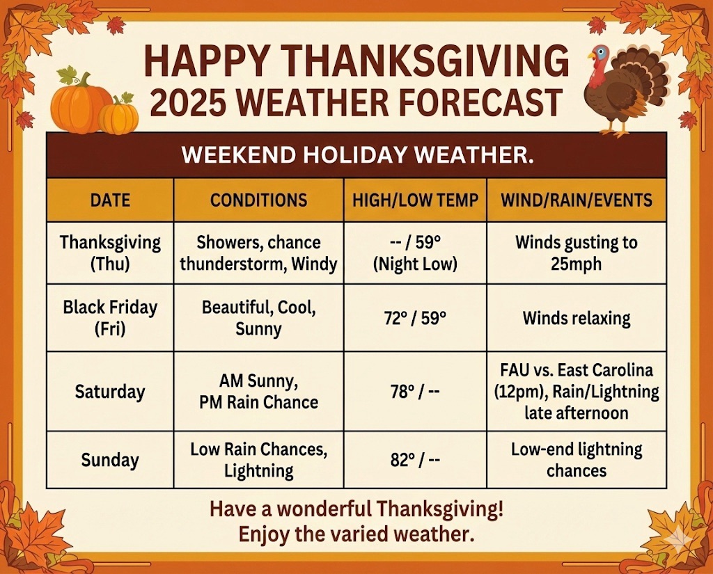
🎢 Thursday Nights: The Weekend Outlook
- Focus: Friday through Monday.
- What you get: The all-important weekend forecast. This issue also includes our Drought Monitor Update (fresh off the press from Thursday morning) and a specific look at Theme Park weather for your weekend getaways.
Plus: The Extras
Every issue now includes:
- 🚀 Space Coast Launch Schedule: The next 3 launches from the Cape, so you never miss a Falcon 9 rumble.
- ⚠️ Hazard Alerts: Clear warnings for specific threats like high winds, lightning risk, or extreme heat.
Join the Community
Stop guessing and start planning. Get the local insights that apps miss delivered straight to your inbox three times a week. It’s the easiest way to stay weather-aware without the noise.